
Global Positioning System (GPS) technology has revolutionized modern agriculture, enabling farmers to achieve unprecedented precision in field operations. In the context of farming, GPS provides real-time location data, allowing for accurate navigation and positioning of equipment such as tractors, seeders, and harvesters. This capability is particularly crucial during planting, where precise seed placement can significantly impact crop yields and resource efficiency.
Planting accuracy is vital for optimizing crop density, ensuring uniform growth, and minimizing resource waste. Inaccurate planting can lead to uneven crop stands, increased competition for nutrients, and inefficient use of inputs like seeds and fertilizers. By utilizing GPS-guided systems, farmers can maintain consistent row spacing and seed depth, promoting healthier plant development and maximizing potential yields.
The adoption of GPS technology in agriculture has seen significant growth. According to the U.S. Department of Agriculture (USDA), as of 2019, GPS systems were used on 40% of all U.S. farm and ranch acreage for on-farm production. Furthermore, a report by GPS World indicates that if broader adoption of precision agriculture technologies continues, the United States could increase its national crop production by 6%, bolstering the agricultural economy.
Understanding how GPS improves planting accuracy is just the beginning; next, we’ll explore the specific tools and techniques that make precision farming possible and how they transform overall crop management.
What Is GPS in Precision Farming?
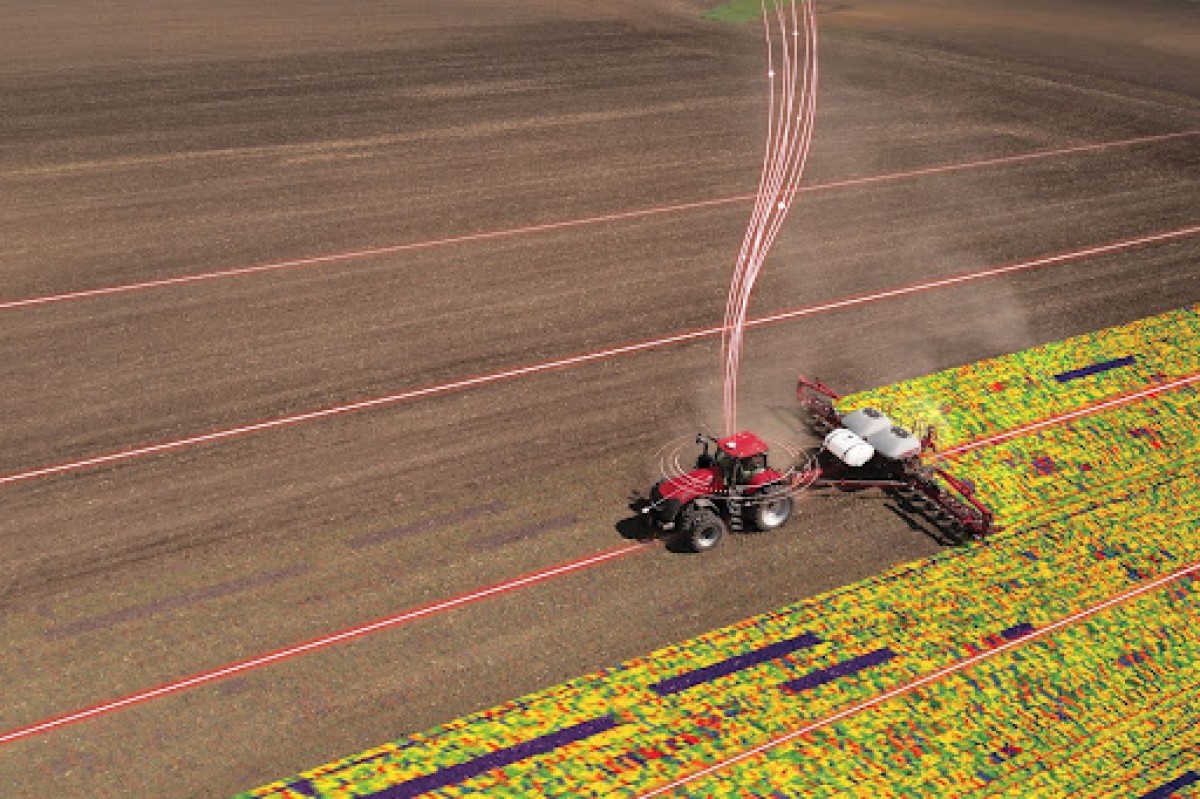
Global Positioning System (GPS), often combined with other satellite navigation systems under the term GNSS (Global Navigation Satellite System), is a technology that provides real-time location data using satellites orbiting the Earth. In precision farming, GPS/GNSS allows farmers to know the exact position of their equipment and fields with remarkable accuracy, often down to a few centimeters.
This technology is integrated directly with tractors, planters, and other field equipment. GPS-enabled tractors can follow precise paths in the field, reducing overlap and missed areas, which saves fuel, time, and labor. Similarly, planters connected to GPS systems can maintain uniform seed spacing and depth, ensuring optimal crop density and growth patterns.
Beyond equipment guidance, GPS technology works hand-in-hand with farm management systems. These platforms collect and analyze field data, such as soil conditions, planting density, and yield results and allow farmers to make informed decisions on irrigation, fertilization, and pest management. By connecting GPS data with farm management software, farmers achieve a fully integrated approach to precision agriculture, increasing efficiency, reducing waste, and improving overall crop productivity.
Importance of Planting Accuracy
Planting accuracy is one of the most critical factors in modern agriculture, as it directly influences crop health, yield, and overall farm efficiency. To fully understand the impact of planting accuracy on crop productivity, it helps to break it down into key areas: seed placement, spacing, and efficient use of resources.
Seed Placement and Optimal Depth
Proper seed placement goes beyond simply putting seeds in the ground. It involves positioning each seed at the precise depth needed for uniform germination and healthy early growth. Incorrect depth can lead to uneven emergence, poor root development, and lower yields.
GPS-guided planting systems allow farmers to maintain consistent depth across the field, reducing seed wastage and supporting stronger, more uniform crop establishment.
Consistent Spacing for Crop Uniformity
Uniform spacing between seeds is vital to prevent overcrowding and competition for sunlight, water, and nutrients. Crops planted too closely may stunt each other’s growth, while those too far apart fail to maximise the field’s productive potential.
Precision planting technology ensures each seed is spaced correctly, resulting in even crop emergence, healthier plants, and higher yields. This consistency also simplifies management practices such as irrigation, fertilization, and harvesting.
Enhancing Resource Efficiency
Accurate planting reduces the unnecessary use of seeds, fertilizers, and water, which lowers input costs and benefits the environment. When seeds are placed correctly, every plant has access to the nutrients it needs, minimizing waste and maximizing productivity per acre. Integrating GPS and farm management systems further allows farmers to track performance and fine-tune inputs for future seasons, supporting sustainable and profitable farming practices.
How GPS Technology Improves Planting
GPS technology has revolutionized modern agriculture by enhancing planting precision and operational efficiency. By integrating GPS with farm machinery, farmers can achieve optimal seed placement, reduce resource wastage, and improve overall crop yields.
Some of the major benefits are as follows:
Auto-Steering and Guidance
Auto-steering systems utilize GPS to guide tractors along straight, consistent paths, minimizing human error. This technology ensures precise row alignment, reducing overlaps and skips during planting. According to a study by the USDA, more than 50% of acres planted to major crops like corn and soybeans are now managed using auto-steer and guidance systems, leading to decreased energy costs and lower input use.
Field Mapping and Boundaries
GPS enables the creation of detailed digital maps of farm fields, marking boundaries and identifying variability zones. This mapping allows for accurate seed placement, reducing wastage and ensuring uniform crop emergence. Automated field mapping also aids in strategic planning of planting patterns and crop rotations, optimizing land use and resource allocation.
Variable Rate Planting
Variable Rate Technology (VRT) leverages GPS data to adjust seeding rates according to specific field zones. This approach ensures that areas with higher yield potential receive more seeds, while less fertile zones receive fewer, optimizing input use and enhancing crop uniformity. Implementing VRT can increase crop yields by up to 20% compared to traditional uniform seeding methods.
Reduced Overlaps and Skips
GPS-guided planting systems minimize overlaps and skips, leading to more efficient use of seeds, fertilizers, and water. This precision reduces input costs and environmental impact, contributing to sustainable farming practices. Additionally, eliminating overlaps and skips ensures uniform crop growth and maximizes yield potential.
Night and Low-Visibility Operations
GPS technology allows for accurate planting operations during nighttime or low-visibility conditions. By providing precise guidance, GPS systems enable farmers to extend working hours and maintain planting accuracy, even in challenging visibility situations. This capability enhances productivity and ensures timely planting, crucial for optimal crop development.

Benefits of GPS-Enabled Planting
GPS-enabled planting offers multiple advantages for modern farmers, improving both productivity and sustainability. By providing precise guidance for equipment and seed placement, GPS technology transforms how crops are planted and managed. Key benefits include:
-
Increased Yields: GPS-guided planting ensures uniform seed spacing and optimal depth, promoting healthy crop emergence. Fields planted with GPS assistance can see yield improvements of up to 10–15% compared to traditional methods.
-
Fuel and Input Savings: Accurate guidance reduces overlaps and skips, cutting unnecessary fuel consumption and lowering seed and fertilizer usage. Some farmers report fuel savings of 5–10% annually due to more efficient field operations.
-
Reduced Labor Requirements: Automated steering and GPS guidance allow a single operator to manage larger areas with less fatigue, reducing labor costs and improving efficiency during planting seasons.
-
Environmental Benefits: Minimizing overlaps and optimizing input application decreases runoff of fertilizers and chemicals into surrounding ecosystems. This precision helps support sustainable agriculture practices and reduces the farm’s environmental footprint.
Overall, GPS-enabled planting not only boosts yields and reduces costs but also empowers farmers with the precision and efficiency needed to meet growing food demands sustainably.
Tools and Equipment That Use GPS
GPS technology is now widely integrated into a variety of agricultural tools and equipment, enabling precision farming practices that improve efficiency, reduce waste, and enhance yields. Modern farms rely on several key GPS-enabled tools to optimize planting and field management.
-
Tractors: GPS-enabled tractors can follow precise paths across fields using auto-steering systems. This reduces overlaps, skips, and operator fatigue, ensuring efficient fuel use and accurate field coverage. GPS-guided tractors have become a cornerstone of precision agriculture in the U.S., managing a significant portion of row crop acreage.
-
Planters and Seeders: Precision planters use GPS to control seed spacing, depth, and rate. This ensures uniform crop emergence and maximizes yield potential while minimizing seed waste. The integration of GPS with variable-rate technology allows for planting that adapts to soil variability within fields.
-
Sprayers: GPS-enabled sprayers deliver fertilizers, herbicides, and pesticides with high accuracy, reducing chemical use and preventing over-application. Targeted spraying minimizes environmental impact while maintaining effective crop protection.
-
Drones: Agricultural drones equipped with GPS capture high-resolution imagery and field data. They can identify problem areas, monitor crop health, and even guide planting or spraying in hard-to-reach areas. Drones allow farmers to make data-driven decisions efficiently and with precision.
-
Other Equipment: Other GPS-enabled equipment includes soil sensors, yield monitors, and irrigation controllers, all contributing to a fully integrated precision agriculture ecosystem. These tools collect and analyze real-time data, allowing farmers to optimize operations across planting, growing, and harvesting stages.

Challenges in GPS Adoption for Precision Agriculture
While GPS technology offers significant advantages in precision agriculture, its adoption faces several challenges, particularly in rural areas. These challenges encompass economic constraints, limited infrastructure, and a lack of technical expertise.
1. High Initial Costs
The upfront investment for GPS-enabled machinery, including tractors, planters, and auto-steering systems, can be a major barrier for many farmers. Software subscriptions, maintenance, and updates add to the financial burden, making it difficult for smaller farms to adopt these technologies.
As reported by the U.S. Government Accountability Office (GAO), 27% of U.S. farms and ranches used precision agriculture technologies in 2023. The report also notes that high up-front acquisition costs for precision agriculture technologies have discouraged broader adoption, particularly among smaller farms with limited resources or access to capital.
This data underscores that high acquisition costs remain a significant barrier, particularly for small and mid-sized farms with limited access to capital.
2. Limited Internet Connectivity
Many rural areas suffer from inadequate broadband infrastructure, which is essential for the effective use of GPS technology in agriculture. Without reliable internet access, real-time data transfer becomes challenging, hindering the functionality of GPS-enabled equipment. The lack of broadband and wireless service in rural areas has been a major barrier to the adoption of precision agriculture.
3. Lack of Technical Expertise
The effective use of GPS technology requires a certain level of technical knowledge and skills. Farmers without access to training programs may struggle to operate and maintain GPS-enabled equipment. A study in Nebraska identified a lack of qualified labor to manage digital agriculture technologies as a significant barrier to adoption.
4. Resistance to Change
Traditional farming practices are deeply ingrained, and some farmers may be hesitant to adopt new technologies due to unfamiliarity or perceived risks. Behavioral barriers, such as reluctance to change and skepticism about the benefits of new technologies, can impede the adoption of GPS in agriculture.
5. Infrastructure Deficiencies
Beyond internet connectivity, other infrastructure issues, such as unreliable electricity supply and poor road networks, can affect the implementation of GPS technology. Inadequate infrastructure can lead to equipment malfunction, delays in data transmission, and increased operational costs.
GPS vs Traditional Planting Methods
GPS-enabled planting offers a level of precision that traditional methods cannot match, resulting in more efficient use of seeds, fertilizer, and labor. Key differences include seed spacing consistency, reduction of overlaps and skips, and overall input efficiency.
| Feature | GPS-Enabled Planting | Traditional Planting |
|---|---|---|
| Seed Spacing | Uniform, precise spacing based on GPS and variable rate technology. | Often irregular, depending on operator skill. |
| Overlap and Skips | Minimal overlap or skips; straight rows are maintained automatically. | Higher risk of overlaps and missed areas due to human error. |
| Input Waste (Seeds & Fertilizer) | Reduced waste by applying inputs only where needed, improving cost efficiency. | Higher waste due to uneven application and overlapping passes. |
| Operational Efficiency | Higher efficiency; fewer passes needed, reduced labor, and fuel usage. | Lower efficiency; more passes may be required, increasing labor and fuel costs. |
| Crop Uniformity | More consistent emergence and growth across the field. | Uneven growth due to inconsistent spacing and depth. |
Future of GPS in Farming
The role of GPS in agriculture is expected to grow significantly as it converges with other advanced technologies. What started as a tool for straight rows and accurate planting has now become part of a larger ecosystem that includes artificial intelligence (AI), robotics, and advanced data analytics. The future of GPS in farming looks transformative in several ways:
Integration with Artificial Intelligence (AI)
AI is increasingly being paired with GPS data to create predictive and prescriptive insights. By analyzing soil conditions, weather forecasts, and yield history, AI systems can guide GPS-enabled machinery to make smarter planting and input decisions.
This fusion allows farmers to maximize yields while minimizing waste. According to MarketsandMarkets, the AI in agriculture market is projected to grow from $1.7 billion in 2023 to $4.7 billion by 2028, driven by demand for precision farming solutions.
Autonomous Tractors and Robotics
GPS technology underpins the operation of autonomous tractors and robotic planters. These machines can navigate fields independently, planting or applying inputs with minimal human intervention. Companies like John Deere have already introduced fully autonomous tractors, signaling the beginning of large-scale automation in farming. This not only reduces labor requirements but also ensures consistent performance around the clock.
Real-Time Data Analytics
The combination of GPS with cloud-based farm management systems enables real-time data analytics. Farmers can instantly monitor seed placement, fertilizer use, and crop performance from mobile devices or control centers.
By integrating GPS with IoT sensors and drones, farmers can make immediate decisions based on live field conditions. A report from Grand View Research estimates that the global precision farming market, which heavily relies on GPS and analytics, will reach $22.2 billion by 2030, showcasing the rapid adoption of data-driven decision-making.
Partner with H&R Agri-Power for Proven GPS Solutions
Precision planting powered by GPS has fundamentally reshaped modern agriculture. By delivering uniform seed spacing, minimizing overlaps and skips, and optimizing input usage, GPS-enabled systems drive higher yields, reduce resource waste, and enhance overall crop consistency.
From auto-steering tractors to intelligent field mapping and variable-rate planting, GPS is the cornerstone of sustainable, efficient, and profitable farming. To fully unlock these benefits on your farm, consider partnering with a trusted provider like H&R Agri-Power.
With a dedicated Precision Ag Department, they offer advanced GPS guidance systems, field mapping, nutrient management tools, and expert support to help farmers integrate precision farming technologies effectively.

Frequently Asked Questions
How accurate is GPS planting?
With RTK (Real-Time Kinematic) GPS, accuracy can be as precise as 1–2 cm, ensuring near-perfect seed placement. Standard GPS offers about 20–30 cm accuracy, which is less precise. This level of accuracy helps farmers maximize yield potential by avoiding wasted space and ensuring uniform crop growth.
Do small farms benefit from GPS?
Yes. Even on smaller acreages, GPS reduces wasted seed, fertilizer, and fuel. This helps improve efficiency and boosts profitability over time. Studies show that smaller farms adopting precision technology often see faster ROI because even small savings on inputs make a big impact.
Is GPS planting expensive?
Upfront costs for equipment and subscriptions can be high, but the return on investment (ROI) comes from reduced input use, lower fuel costs, and higher yields. Many farmers see payback within a few seasons, especially when equipment is used across planting, spraying, and harvesting operations.
Can GPS planting work on uneven fields?
Yes. GPS systems integrate with digital field mapping software to adapt to slopes, contours, and irregular field shapes. This ensures consistent coverage even on challenging terrain, allowing operators to plant in areas that would otherwise be inefficient or error-prone.
What’s the difference between GPS and RTK GPS?
Standard GPS is accurate within about 20–30 cm, while RTK GPS delivers 1–2 cm accuracy, making it far more suitable for precision planting and input application. Farmers who need exact row spacing and minimal overlaps almost always choose RTK for maximum efficiency.
Does GPS planting reduce environmental impact?
Yes. By minimizing overlaps and skips, GPS reduces excess use of seeds, fertilizers, and chemicals, lowering runoff and promoting sustainable practices. This makes it a key tool for farms adopting climate-smart agriculture approaches.
Can GPS be used during night or poor visibility?
Absolutely. GPS guidance allows accurate planting in low-light or foggy conditions, ensuring work can continue beyond daylight hours. This helps farmers take advantage of narrow weather windows during peak planting seasons.
Is training required to use GPS equipment?
Most systems are designed with user-friendly interfaces, but basic training is recommended to get the most out of advanced features like variable-rate planting and field mapping. Many providers, such as H&R Agri-Power, offer support and training services to help farmers quickly adopt new systems.